Menu
Excerpts
Exhibits
Collections
Originals
Categories
Map
Search
Idea
rivers
74
Filter by:
Date Published
Filter by published date
Published On or After:
Published On or Before:
Filter
Cancel
Viewing 31–60 of 74 results.
Go to first page
The Remapping of America—From an Indigenous Point of View
New maps can revive Cherokee place names in Southern Appalachia and restore crucial knowledge amid an environmental catastrophe.
by
Gregory D. Smithers
via
The New Republic
on
January 17, 2022
Wild Rice Waters
The resurgence of the wild rice harvest seeks to tells the story of settler colonialism, tribal kinship and ecological stewardship.
by
Emily Hicks
,
Melody R. Stein
via
Places Journal
on
June 14, 2021
The Lost Rivers of Owens Valley
Water—who owns it, who uses it—has shaped this landscape from the Paiutes’ irrigation canals to the Los Angeles aqueduct.
by
Frederic Wehrey
via
New York Review of Books
on
February 16, 2021
Harold Fisk’s Meander Maps of the Mississippi River
A geologist and cartographer dreamed up a captivating, colorful, visually succinct way of representing the river's fluctuations through space and time.
via
The Public Domain Review
on
August 30, 2020
Tom Paine’s Bridge
We do not often think of Paine as a revolutionary inventor. But in a very real sense, that is what he believed himself to be.
by
Edward G. Gray
via
Commonplace
on
April 16, 2020
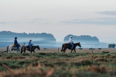
Keeping the Country
In southwest Florida, the Myakka River Valley — a place of mystery and myth — is under threat of development.
by
Michael Adno
via
The Bitter Southerner
on
January 28, 2020
The Missouri River Flood Hits a Historic Native American Homeland
In the wake of devastating floods, one writer reflects on the importance of place to Great Plains Indians.
by
Ian Frazier
via
The New Yorker
on
April 3, 2019
The Role of Water in African American History
Have historians privileged land-based models and ignored how African Americans participated in aquatic activities?
by
Tyler D. Parry
via
Black Perspectives
on
May 4, 2018
Two Hundred Years on the Erie Canal
A digital exhibit on the history and legacy of the canal.
by
Heidi Zimmer
,
Dan Ward
via
Digital Public Library of America
on
January 1, 2018
The River That Became a Warzone
The US-Mexico border wall is disrupting and destroying the lives of a united binational community.
by
Zeke Peña
via
The Nib
on
December 21, 2017
partner
Canals 1820-1890
An interactive map of U.S. canals in the first half of the 19th century.
by
Ed Ayers
,
Robert K. Nelson
,
Scott Nesbit
,
Justin Madron
,
Nathaniel Ayers
,
Beaumont Smith
via
American Panorama
on
December 1, 2015
A Border Crosses
After a Rio Grande flood shifted a 437-acre strip of land from Mexico to Texas, the area was the site of a long border dispute.
by
Paul A. Kramer
via
The New Yorker
on
September 20, 2014
This 19th Century Map Could Have Transformed the West
According to John Wesley Powell, outside of the Pacific Northwest, the arid lands of the west could not be farmed without irrigation.
by
Susan Schulten
via
The New Republic
on
June 9, 2014
New York - Before the City
Mannahatta's fascinating pre-city ecology of hills, rivers, wildlife when Times Square was a wetland and you couldn't get delivery.
by
Eric W. Sanderson
via
TED
on
July 1, 2009
Harriet Tubman and the Second South Carolina Volunteers Bring Freedom to the Combahee River
The story of how Harriet Tubman led 150 African American soldiers to rescue over 700 former slaves freed five months earlier by the Emancipation Proclamation.
by
Edda Fields-Black
via
History Uncut
on
June 19, 2024
Remembering the 1932 Ford Hunger March: Detroit Park Honors Labor and Environmental History
On March 7, workers at the Ford Rouge River plant marched for better working conditions. Almost a century later, a quiet park honors their memory.
by
Paul Draus
via
The Conversation
on
April 2, 2024
From the Reservation to the River: On the Complexities of Writing About a Native Childhood
Remembering the river helps me forget, at least for a moment, the challenges, fears, and feelings of inadequacy I experienced in my childhood.
by
Deborah Taffa
via
Literary Hub
on
February 28, 2024
The Epic History of the Endangered Species Act
The two-volume ‘Codex of the Endangered Species Act’ takes a long look back — and forward.
by
Michelle Nijhuis
via
High Country News
on
December 1, 2023
In California, Climate Chaos Looms Over Prisons — and Thousands of Prisoners
How decades-old decisions to build two California prisons in a dry lakebed and a chaotic climate left 8,000 incarcerated people at risk.
by
Susie Cagle
via
The Marshall Project
on
October 24, 2023
original
Mettlesome, Mad, Extravagant City
In the streets of New York, we try to imagine the city as Walt Whitman, and other artists of his time, experienced it.
by
Ed Ayers
on
September 21, 2023
original
A Gateway to the Past
The Arch in St. Louis stands as a monument to contradictory histories.
by
Ed Ayers
on
September 13, 2023
When American Governors and Moguls Came Together to Prevent Environmental Catastrophe
A historic 1908 conference transcended party and personal interest for the ‘common good.'
by
Adam M. Sowards
via
Zócalo Public Square
on
August 17, 2023
The Roots of Environmental (In)justice in the Early Republic
Development and dispossession as a two-pronged conquest.
by
John William Nelson
via
The Panorama
on
July 11, 2023
An Indianapolis Archivist’s Curiosity Revives Historical Truths
A Black cemetery by the site of the former Greenlawn Cemetery in Indianapolis is now a point of contention as the city plans to develop the area.
by
Mary Lee Pappas
via
Arts Midwest
on
June 29, 2023
Reclaiming Native Identity in California
The genocide of Native Americans was nowhere more methodically savage than in California. A new state initiative seeks to reckon with this history.
by
Ed Vulliamy
via
New York Review of Books
on
June 1, 2023
Phosphorus Saved Our Way of Life—and Now Threatens to End It
Fertilizers filled with the nutrient boosted our ability to feed the planet. Today, they’re creating vast and growing dead zones in our lakes and seas.
by
Elizabeth Kolbert
via
The New Yorker
on
February 27, 2023
original
Rainbows and Disappointments
There is a long and storied tradition of feeling underwhelmed by the natural spectacle of Niagara Falls. Still, the visitors keep coming.
by
Ed Ayers
on
December 13, 2022
partner
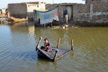
A History of U.S. Interference Worsened Pakistan’s Devastating Floods
Development aid targeted for water as an economic and technical matter had environmental and financial consequences.
by
Maira Hayat
via
Made By History
on
October 12, 2022
How US Corporations Poisoned This Indigenous Community
These invisible chemicals changed the Mohawk way of life. They’re probably already in you, too.
by
Liz Scheltens
via
Vox
on
August 16, 2022
The Toxic History of the Salton Sea
A new book catalogs the alarming events that created one of the West’s most polluted bodies of water.
by
Kyle Paoletta
via
The Nation
on
August 10, 2022
View More
30 of
74
Filters
Filter Results:
Search for a term by which to filter:
Suggested Filters:
Idea
water
water control
environmental degradation
maps
dams
landscape
geography
conservationism
infrastructure
pollution
Person
John Wesley Powell