Despite the lack of roads and gas stations on the moon, Standard Oil recognized the marketing potential of the Apollo program, and it hired General Drafting’s competitor Hammond Incorporated of Maplewood, New Jersey, to produce two offset lithographic maps (19” x 24”). Printed sometime after November 9, 1967, when NASA launched Apollo 4, they combine lunar geography, photography, and spacecraft illustrations, along with celestial facts and purple prose: “The pale moon hangs like a distant target against the jet-black background of outer space,” Map of the Moon explains.
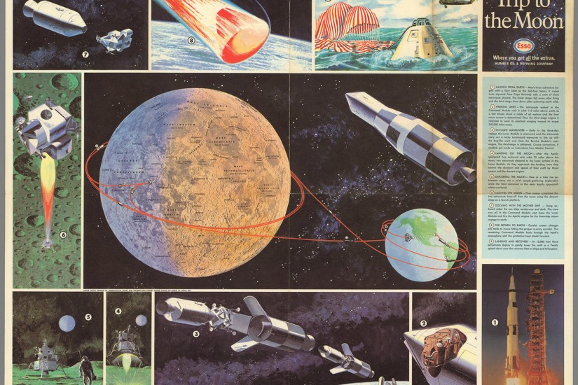
Its companion, Trip to the Moon, charts a potential route for the astronauts Michael Collins, Neil Armstrong, and Buzz Aldrin, with the “bug-like” lunar lander touching down close to the Ocean of Storms, one of five potential landing sites identified by the Apollo 11 press kit that NASA released on July 6.
Unlike the typical Esso road map, or the pictorial maps Standard Oil also distributed for kids in the backseat, Map of the Moon and Trip to the Moon are printed single sided. Instead of the much more economical recto-verso combination, each has a completely blank back. Their physicality anticipates collection and display, rather than use in the car, and their visual style appeals to either a child’s bedroom or a parent’s den. (Today, collectors might pay hundreds for the former freebies.)
While the red, white, and blue of Esso’s (or Humble’s) logo is prominent on the maps, American patriotism is virtually non-existent. An inset photograph on Trip to the Moon shows “USA” stamped on a Saturn V rocket, and includes a small NASA credit, but nowhere else does it mention the United States or the space agency by name, although the word “astronaut” subtly reminds viewers this will not be a Russian cosmonaut mission.*
Similarly, Map of the Moon eschews the nationalistic rhetoric of the Space Race and instead notes the Soviet Union’s “historic feat” of photographing the far side of the moon, in October 1959. The place names Moscow Sea and Tsiolkovsky reinforce Russia’s role in lunar exploration. Though it does credit the U.S. Air Force for providing the map’s base photo mosaic, it makes no reference to NASA. Instead, it encourages users to “use this chart to follow the news of future moon missions as the second phase unfolds and actual landings and exploration are made by man”—implicitly landings and exploration made by men of any nation.